Archive for July, 2009

The Three Equators – Real and Unreal

Saturday, July 25th, 2009

Today we visited the equator. Well in fact we visited three “equators” – one legitimately incorrect, one deliberately fake, and the real thing which runs next to a major road and through a pile of dust, litter and rocks that happened to be vacant land for sale. For sale at a high price, I imagine, given the tourist dollars at stake.

The whole day was a slightly surreal experience for a geo-nerd like myself. What surprises me is just how few people have bothered to trot through there with a GPS and expose the Intiñan Solar Museum – claiming to straddle the true equator – for the fraud that it is.

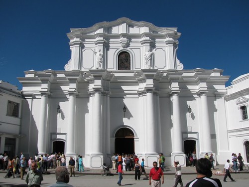
Let’s start with the official monument. An impressive stone obelisk structure constructed around 27 years ago, housed in the middle of a very well serviced touristy fun park complete with multiple restaurants, museums and a planetarium.

IMG_3690

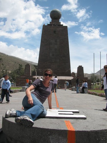
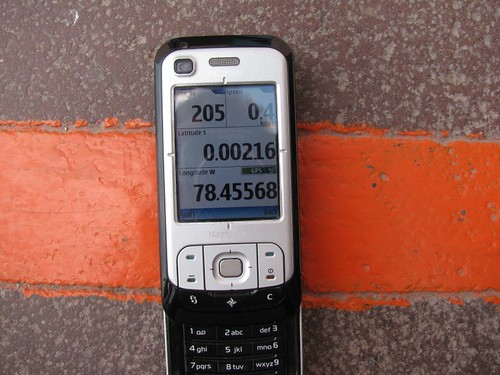
It’s common knowledge that this monument is located 240m south of the true equator, something which my GPS – showing 0.00216 degrees south – agreed with exactly:

IMG_3682

Given it’s 27 year age, dating back well before the commercial availability of GPS, they did a pretty good job in choosing its location. I can also forgive them for failing to mention anywhere that this isn’t the real thing, letting throngs of tourists happily think they’re jumping between the northern and southern hemispheres.

So we move onto the “real” equator, the Intiñan Solar Museum described by Lonely Planet as being next door, and “supposedly on the site of the real equator”.

They’re certainly not bashful with their claims, sporting multiple large signs assuring visitors that this is the “real equator as calculated with GPS”.

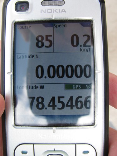
Being a natural skeptic, I knew something was amiss as soon as we walked up to the entrance. We were still a good 130m south of 00°00′00”. Suspicions were soon confirmed once I stood on their theatrically adorned equatorial line. No dice:

Intiñan Solar Museum: No this is not the equator

The tour guides here have indulged in range of “experiments” to demonstrate the mystical properties of the equatorial line, including the famous (and repeatedly debunked) anti/clockwise water draining one, as well some more patently ridiculous ones involving balancing eggs and humans becoming mysteriously weak when standing on the equator.

These became even more amusing once we let our guide know that we were onto their dirty little secret of being over 100m south of the real deal.

Our guides’ first line of defense was the recommendation that we “need to use code 69 for our GPS when in South America” for it to give a correct reading. A classic “baffle them with bullshit” approach. He then assured us that our commercial GPS was inaccurate and that their location had in fact been confirmed by the US Army with military grade GPS equipment.

US Army? Really?

Not only that, but the US Army had issued them with a certificate stating that they are indeed located on the true equator.

The US Army… verifying the location of a privately owned tourist trap, and then issuing them a certificate? This guy was an absolute classic, though I guess he was just following the script. I asked if we would get to see the certificate at the end of the tour, and he confirmed that yes, we would.

I really looked forward to snapping a photograph of this certificate!

Sadly, though, at the end of the tour, when I asked to see the certificate, he apologized and said “the certificate is in my bosses house, so I can’t get it because he’s not here”.

Nice. So we returned hit the road again for our final search. We’d been looking for the real equator for a few hours at this point, and I for one was quite excited at actually getting there.

The result was, though, sadly underwhelming:

Yep, this is the real equator. Dusty. Windy.

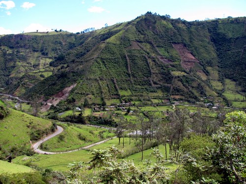
Turns out the real line runs through a vacant plot of land, out on a fairly inconvenient angle across the highway. The land is, of course, for sale.

Real Equator, with the monument in background

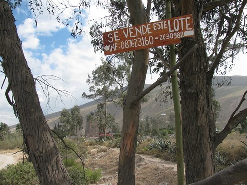
Interestingly the plot is adjacent to both the official monument (you can see it in the above photo), and another plot of land owned by the Intiñan charlatans, used for bus and car parking. I expect they’re both trying to get their hands on it so that maybe, just maybe, the truth can be revealed to the tourist masses. For a modest sum of course.

On The Real Equator

So far I’ve only managed to locate one other fellow geo-nerd who has been here and verified this. Our co-ordinates are in agreement, as is Google’s satellite imagery. This is the real equator.

Reflections at the 3-month mark

Wednesday, July 22nd, 2009

(Also see the backlog from Cartagena, Salento & the coffee region, Cali, and Popayán.)

It was time to move on from Colombia, and after 12 hours of buses and a night in the cold, depressing border town of Ipiales we entered Ecuador yesterday with a minimum of hassle – particularly compared with our last overland crossing into Panama.

IMG_3523

In the past week we’ve had a run of perfect days followed by hellish, “I’m sick of this shit” days. Generally it’s long bus trips surrounded by noisy Colombian people with crap action movies shown at top volume combined with suicidal drivers (honestly the worst I’ve ever seen) that put us in those moods. Then to arrive in a ho-hum sort of place does little to lift it.

I wonder if this is a window into the bi-polar experience; to experience great days at the hot springs (complete with the fastest, roughest water slide around, extending 52m down the hill) meeting great people, drinking great coffee and eating great steak.

IMG_3544

The next day arguing with indifferent, moronic ticket sellers at the bus terminal, coming down with a nasty cold, motion sickness passing the Andes at > 3000m, being too spaced out to enjoy the view, haggling with 3 taxi drivers in a day, arriving at what is supposed to be the city’s best hotel ($30) to find that the sauna, Turkish bath (what is that, anyway?) and WiFi are all broken. I’m the first to admit I have a short tether, but it really adds up to an anger management exercise.

Then to find some serenity away from the cities, not devastated by human traffic and human filth, does wonders, as it has done up here in the hills surrounding Otovalo, Ecuador at 2900m. Aside: I never imagined feeling so cold just 19 minutes north of the equator.

IMG_3572

To understand “human filth”, imagine traveling through the incredible Andean landscape, with bottles, bricks, paper, plastic, cardboard strewn in every direction, sitting behind locals (both indigenous and those of European descent) watching each one take their turn to open the bus window – or car door, or the front door of their house – and throw trash onto the street. Signs everywhere imploring citizens to keep the place clean seem destined to forever go unheeded. To me it’s civilization, or lack thereof, at its very worst.

IMG_3560

Places that are neat, tidy, and where most of the facilities are functional are almost invariably operated by foreigners. Throughout the trip we’ve had to accept that supporting local operators invariably means tolerating woeful inefficiency and stuff generally not working as expected / advertised. Is this a cause or a symptom of poor countries struggling to keep an upward trajectory to their development?

IMG_3106

Travel fatigue is definitely present. We’ve perhaps also made the mistake of looking forward to the next phase – Europe – a little too early. Talk of epic bike rides and French gastronomic adventures make it difficult to stay focused on extracting maximum value from the remainder of this continent. It’s easy to imagine Europe as being much less effort to traverse, although we need to remember that here we’ve had the luxury of passable Spanish ability. Local language skills are going to be decidedly absent for most of the rest of the trip.

Michael Jackson Graffiti Memorial in Cartagena

Popayán

Wednesday, July 22nd, 2009

IMG_3479

We found another coffee paradise, thanks to the perfectly located Juan Valdez – just like Starbucks, but with drinkable coffee and outdoor ambiance. This one even had WiFi. Heaven for the nerds. The basic story of Juan Valdez was to create a brand that Americans could pronounce, in order to promote the Colombian coffee industry. It was a spectacular success.

IMG_3486

Popoyan is a beautiful colonial town, and we hoped to enjoy some serenity after the intensity of big city life in Cali. Incredibly, though, the place has some serious bustle. It’s a university town and people wander around with a sense of purpose – we were overtaken by pedestrians for the first time since New York!

IMG_3506

We also enjoyed some high altitude hot springs, complete with a 52 meter water slide than had me slinging down the hill at speeds previously unimaginable, albeit on concrete of questionable smoothness. The smell of the sulphurous water stayed with us for quite some time after:

IMG_3496

Unfortunately the hostel, despite being very well equipped & run – our room complete with separate living area & couch – was dominated by traffic noise 24 hours a day. So we departed fairly quickly.

Continuing south to Cali

Wednesday, July 22nd, 2009

Cali, the home of salsa as it is invariably called. It’s a fitting title, as we honestly could not find much else of interest in the city, save for a zoo.

IMG_3452

Down at around 1000m above sea level, it’s hot during the day, and the tropical sun just as scorching, but cools down to a very agreeable temperature at night. Which explains why the tourists tend to sleep all day and dance badly most of the night.

It’s an ugly city, frankly. And while watching the locals dance with such fervor, exhibiting what is a true mating display, had appeal, the ear-destroying volume at which this happens and the super late nights prevented us from really enjoying it. The cab driver on the way home confirmed our suspicions by pointing out “hotels by the hour” with much excitement.

IMG_3447

We had an incredible Argentine bife de chorizo a la parilla (very tasty porterhouse steak) on the final night which was a nice way to finish. Seeing a slightly crazy looking guy carrying a shotgun down our dark street was less so.

Salento & The Coffee Region

Wednesday, July 22nd, 2009

IMG_3433

We flew from Cartagena via Bogota to Armenia, the gateway to the Zona Cafetera; or coffee growing region. This sort of trip is probably the closest I will come to a pilgrimage.

Although I guess being in the SF bay area (i.e. the heart of the computing & the internet) was also a pilgrimage for me. Anyway – coffee, it’s inextricably linked to the business of being a computer nerd, and we do have to admit to a fairly serious addiction that has been starved throughout Latin America.

IMG_3327

But a sudden, ready availability of the quality stuff had us falling right off the wagon, sipping the stuff like water, trying to get our fill before the inevitable return to crap coffee. The cute coffee shop near the plaza, Jesus Martin, employed a young barista who showed incredible talent. Apparently he learned his craft by watching videos on Youtube. Needless to say we spent a lot of time in there.

IMG_3385

We hopped on board the usual array of hikes and coffee farm tours that the gringo trail here offers. Quite satisfying, and I feel like I now fully understand the life cycle of a coffee bean. It remains slightly shocking just how much human efforts goes into a single shot of espresso.

IMG_3347

At around 1900m the climate in the region was a refreshing change from the tropics.

IMG_3280